Appendix A to Part 150 - Noise Exposure Maps
PART A -- GENERAL
Sec. A150.1 Purpose.
Sec. A150.3 Noise descriptors.
Sec. A150.5 Noise measurement
procedures and equipment.
PART B -- NOISE EXPOSURE MAP
DEVELOPMENT
Sec. A150.101 Noise contours and
land usages.
Sec. A150.103 Use of computer
prediction model.
Sec. A150.105 Identification of
public agencies and planning agencies.
PART C -- MATHEMATICAL DESCRIPTIONS
Sec. A150.201 General.
Sec. A150.203 Symbols.
Sec. A150.205 Mathematical
computations.
PART A -- GENERAL
Sec. A150.1 Purpose.
(a) This appendix establishes a uniform
methodology for the development and preparation of airport noise exposure
maps. That methodology includes a single system of measuring noise at
airports for which there is a highly reliable relationship between
projected noise exposure and surveyed reactions of people to noise along
with a separate single system for determining the exposure of individuals
to noise. It also identifies land uses which, for the purpose of this part
are considered to be compatible with various exposures of individuals to
noise around airports.
(b) This appendix provides for the use
of the FAA's Integrated Noise Model (INM) or an FAA approved equivalent,
for developing standardized noise exposure maps and predicting noise
impacts. Noise monitoring may be utilized by airport operators for data
acquisition and data refinement, but is not required by this part for the
development of noise exposure maps or airport noise compatibility
programs. Whenever noise monitoring is used, under this part, it should be
accomplished in accordance with Sec. A150.5 of this appendix.
Sec. A150.3 Noise descriptors.
(a) Airport Noise Measurement.
The A-Weighted Sound Level, measured, filtered and recorded in accordance
with Sec. A150.5 of this appendix, must be employed as the unit for the
measurement of single event noise at airports and in the areas surrounding
the airports.
(b) Airport Noise Exposure. The
yearly day-night average sound level (YDNL) must be employed for the
analysis and characterization of multiple aircraft noise events and for
determining the cumulative exposure of individuals to noise around
airports.
Sec. A150.5 Noise measurement
procedures and equipment.
(a) Sound levels must be measured or
analyzed with equipment having the "A" frequency weighting, filter
characteristics, and the "slow response" characteristics as defined in
International Electrotechnical Commission (IEC) Publication No. 179,
entitled "Precision Sound Level Meters" as incorporated by reference in
part 150 under §150.11. For purposes of this part, the tolerances allowed
for general purpose, type 2 sound level meters in IEU 179, are acceptable.
(b) Noise measurements and documentation
must be in accordance with accepted acoustical measurement methodology,
such as those described in American National Standards Institute
publication ANSI 51.13, dated 1971 as revised 1979, entitled "ANS --
Methods for the Measurement of Sound Pressure Levels"; ARP No. 796, dated
1969, entitled "Measurement of Aircraft Exterior Noise in the Field";
"Handbook of Noise Measurement," Ninth Ed. 1980, by Arnold P.G. Peterson;
or "Acoustic Noise Measurement," dated Jan., 1979, by J.R. Hassell and K.
Zaveri. For purposes of this part, measurements intended for comparison to
a State or local standard or with another transportation noise source
(including other aircraft) must be reported in maximum A-weighted sound
levels (LAM); for computation or validation of the yearly
day-night average level (Ldn), measurements must be reported
in sound exposure level (LAE), as defined in Sec. A150.205 of
this appendix.
PART B -- NOISE EXPOSURE MAP
DEVELOPMENT
Sec. A150.101 Noise contours and
land usages.
(a) To determine the extent of the noise
impact around an airport, airport proprietors developing noise exposure
maps in accordance with this part must develop Ldn contours.
Continuous contours must be developed for YDNL levels of 65, 70, and 75
(additional contours may be developed and depicted when appropriate). In
those areas where YDNL values are 65 YDNL or greater, the airport operator
shall identify land uses and determine land use compatibility in
accordance with the standards and procedures of this appendix.
(b) Table 1 of this appendix describes
compatible land use information for several land uses as a function of
YDNL values. The ranges of YDNL values in Table 1 reflect the statistical
variability for the responses of large groups of people to noise. Any
particular level might not, therefore, accurately assess an individual's
perception of an actual noise environment. Compatible or noncompatible
land use is determined by comparing the predicted or measured YDNL values
at a site with the values given. Adjustments or modifications of the
descriptions of the land-use categories may be desirable after
consideration of specific local conditions.
(c) Compatibility designations in Table
1 generally refer to the major use of the site. If other uses with greater
sensitivity to noise are permitted by local government at a site, a
determination of compatibility must be based on that use which is most
adversely affected by noise. When appropriate, noise level reduction
through incorporation of sound attenuation into the design and
construction of a structure may be necessary to achieve compatibility.
(d) For the purpose of compliance with
this part, all land uses are considered to be compatible with noise levels
less than Ldn 65 dB. Local needs or values may dictate further
delineation based on local requirements or determinations.
(e) Except as provided in (f) below, the
noise exposure maps must also contain and indentify:
(1) Runway locations.
(2) Flight tracks.
(3) Noise contours of Ldn
65, 70, and 75 dB resulting from aircraft operations.
(4) Outline of the airport boundaries.
(5) Noncompatible land uses within the
noise contours, including those within the Ldn 65 dB contours.
(No land use has to be identified as noncompatible if the self-generated
noise from that use and/or the ambient noise from other nonaircraft and
nonairport uses is equal to or greater than the noise from aircraft and
airport sources.)
(6) Location of noise sensitive public
buildings (such as schools, hospitals, and health care facilities), and
properties on or eligible for inclusion in the National Register of
Historic Places.
(7) Locations of any aircraft noise
monitoring sites utilized for data acquisition and refinement procedures.
(8) Estimates of the number of people
residing within the Ldn 65, 70, and 75 dB contours.
(9) Depiction of the required noise
contours over a land use map of a sufficient scale and quality to discern
streets and other identifiable geographic features.
(f) Notwithstanding any other provision
of this part, noise exposure maps prepared in connection with studies
which were either Federally funded or Federally approved and which
commenced before October 1, 1981, are not required to be modified to
contain the following items:
(1) Flight tracks depicted on the map.
(2) Use of ambient noise to determine
land use compatibility.
(3) The Ldn 70 dB noise
contour and data related to Ldn 70 dB contour. When
determinations on land use compatibility using Table 1 differ between Ldn
65-70 dB and the Ldn 70-75 dB, determinations should either
use the more conservative Ldn 70-75 dB column or reflect
determinations based on local needs and values.
(4) Estimates of the number of people
residing within the Ldn 65, 70, and 75 dB contours.
                   TABLE 1_Land Use Compatibility* With Yearly Day-Night Average Sound Levels
----------------------------------------------------------------------------------------------------------------
                                        Yearly day-night average sound level (L[INF]dn[/INF]) in decibels
           Land use            ---------------------------------------------------------------------------------
                                  Below 65        65-70         70-75         75-80        80-85       Over 85
----------------------------------------------------------------------------------------------------------------
          Residential
1  1  1  1  1  1  1  Residenti  Y             N(1)          N(1)          N             N            N
 al, other than mobile homes
 and transient lodgings.
Mobile home parks.............  Y             N             N             N             N            N
Transient lodgings............  Y             N(1)          N(1)          N(1)          N            N
          Public Use
Schools.......................  Y             N(1)          N(1)          N             N            N
Hospitals and nursing homes...  Y             25            30            N             N            N
Churches, auditoriums, and      Y             25            30            N             N            N
 concert halls.
Governmental services.........  Y             Y             25            30            N            N
Transportation................  Y             Y             Y(2)          Y(3)          Y(4)         Y(4)
Parking.......................  Y             Y             Y(2)          Y(3)          Y(4)         N
        Commercial Use
Offices, business and           Y             Y             25            30            N            N
 professional.
Wholesale and retail_building   Y             Y             Y(2)          Y(3)          Y(4)         N
 materials, hardware and farm
 equipment.
Retail trade_general..........  Y             Y             25            30            N            N
Utilities.....................  Y             Y             Y(2)          Y(3)          Y(4)         N
Communication.................  Y             Y             25            30            N            N
 Manufacturing and Production
Manufacturing, general........  Y             Y             Y(2)          Y(3)          Y(4)         N
Photographic and optical......  Y             Y             25            30            N            N
Agriculture (except livestock)  Y             Y(6)          Y(7)          Y(8)          Y(8)         Y(8)
 and forestry.
Livestock farming and breeding  Y             Y(6)          Y(7)          N             N            N
Mining and fishing, resource    Y             Y             Y             Y             Y            Y
 production and extraction.
         Recreational
Outdoor sports arenas and       Y             Y(5)          Y(5)          N             N            N
 spectator sports.
Outdoor music shells,           Y             N             N             N             N            N
 amphitheaters.
Nature exhibits and zoos......  Y             Y             N             N             N            N
Amusements, parks, resorts and  Y             Y             Y             N             N            N
 camps.
Golf courses, riding stables    Y             Y             25            30            N            N
 and water recreation.
----------------------------------------------------------------------------------------------------------------
Numbers in parentheses refer to notes.
*The designations contained in this table do not constitute a Federal determination that any use of land covered
  by the program is acceptable or unacceptable under Federal, State, or local law. The responsibility for
  determining the acceptable and permissible land uses and the relationship between specific properties and
  specific noise contours rests with the local authorities. FAA determinations under part 150 are not intended
  to substitute federally determined land uses for those determined to be appropriate by local authorities in
  response to locally determined needs and values in achieving noise compatible land uses.
Key to Table 1
SLUCM=Standard Land Use Coding Manual.
Y (Yes)=Land Use and related structures compatible without restrictions.
N (No)=Land Use and related structures are not compatible and should be prohibited.
NLR=Noise Level Reduction (outdoor to indoor) to be achieved through incorporation of noise attenuation into the
  design and construction of the structure.
25, 30, or 35=Land use and related structures generally compatible; measures to achieve NLR of 25, 30, or 35 dB
  must be incorporated into design and construction of structure.
Notes for Table 1
(1) Where the community determines that residential or school uses must be allowed, measures to achieve outdoor
  to indoor Noise Level Reduction (NLR) of at least 25 dB and 30 dB should be incorporated into building codes
  and be considered in individual approvals. Normal residential construction can be expected to provide a NLR of
  20 dB, thus, the reduction requirements are often stated as 5, 10 or 15 dB over standard construction and
  normally assume mechanical ventilation and closed windows year round. However, the use of NLR criteria will
  not eliminate outdoor noise problems.
(2) Measures to achieve NLR 25 dB must be incorporated into the design and construction of portions of these
  buildings where the public is received, office areas, noise sensitive areas or where the normal noise level is
  low.
(3) Measures to achieve NLR of 30 dB must be incorporated into the design and construction of portions of these
  buildings where the public is received, office areas, noise sensitive areas or where the normal noise level is
  low.
(4) Measures to achieve NLR 35 dB must be incorporated into the design and construction of portions of these
  buildings where the public is received, office areas, noise sensitive areas or where the normal level is low.
(5) Land use compatible provided special sound reinforcement systems are installed.
(6) Residential buildings require an NLR of 25.
(7) Residential buildings require an NLR of 30.
(8) Residential buildings not permitted.
Sec. A150.103 Use of computer
prediction model.
(a) The airport operator shall acquire
the aviation operations data necessary to develop noise exposure contours
using an FAA approved methodology or computer program, such as the
Integrated Noise Model (INM) for airports or the Heliport Noise Model (HNM)
for heliports. In considering approval of a methodology or computer
program, key factors include the demonstrated capability to produce the
required output and the public availability of the program or methodology
to provide interested parties the opportunity to substantiate the results.
(b) Except as provided in paragraph (c)
of this section, the following information must be obtained for input to
the calculation of noise exposure contours:
(1) A map of the airport and its
environs at an adequately detailed scale (not less than 1 inch to 8,000
feet) indicating runway length, alignments, landing thresholds, takeoff
start-of-roll points, airport boundary, and flight tracks out to at least
30,000 feet from the end of each runway.
(2) Airport activity levels and
operational data which will indicate, on an annual average-daily-basis,
the number of aircraft, by type of aircraft, which utilize each flight
track, in both the standard daytime (0700-2200 hours local) and nighttime
(2200-0700 hours local) periods for both landings and takeoffs.
(3) For landings -- glide slopes, glide
slope intercept altitudes, and other pertinent information needed to
establish approach profiles along with the engine power levels needed to
fly that approach profile.
(4) For takeoffs -- the flight profile
which is the relationship of altitude to distance from start-of-roll along
with the engine power levels needed to fly that takeoff profile; these
data must reflect the use of noise abatement departure procedures and, if
applicable, the takeoff weight of the aircraft or some proxy for weight
such as stage length.
(5) Existing topographical or airspace
restrictions which preclude the utilization of alternative flight tracks.
(6) The government furnished data
depicting aircraft noise characteristics (if not already a part of the
computer program's stored data bank).
(7) Airport elevation and average
temperature.
(c) For heliports, the map scale
required by paragraph (b)(1) of this section shall not be less than 1 inch
to 2,000 feet and shall indicate heliport boundaries, takeoff and landing
pads, and typical flight tracks out to at least 4,000 feet horizontally
from the landing pad. Where these flight tracks cannot be determined,
obstructions or other limitations on flight tracks in and out of the
heliport shall be identified within the map areas out to at least 4,000
feet horizontally from the landing pad. For static operation (hover), the
helicopter type, the number of daily operations based on an annual
average, and the duration in minutes of the hover operation shall be
identified. The other information required in paragraph (b) shall be
furnished in a form suitable for input to the HNM or other FAA approved
methodology or computer program.
Sec. A150.105 Identification of
public agencies and planning agencies.
(a) The airport proprietor shall
identify each public agency and planning agency whose jurisdiction or
responsibility is either wholly or partially within the Ldn 65
dB boundary.
(b) For those agencies identified in (a)
that have land use planning and control authority, the supporting
documentation shall identify their geographic areas of jurisdiction.
PART C -- MATHEMATICAL DESCRIPTIONS
Sec. A150.201 General.
The following mathematical descriptions
provide the most precise definition of the yearly day-night average sound
level (Ldn), the data necessary for its calculation, and the
methods for computing it.
Sec. A150.203 Symbols.
The following symbols are used in the
computation of Ldn;
------------------------------------------------------------------------
                        Measure (in dB)                          Symbol
------------------------------------------------------------------------
Average Sound Level, During Time T............................  L[INF]T[/
                                                                    INF]
Day-Night Average Sound Level (individual day)................  L[INF]dn
                                                                 i[/INF]
Yearly Day-Night Average Sound Level..........................  L[INF]dn
                                                                  [/INF]
Sound Exposure Level..........................................  L[INF]AE
                                                                  [/INF]
------------------------------------------------------------------------
Sec. A150.205 Mathematical
computations.
(a) Average sound level must be computed
in accordance with the following formula:
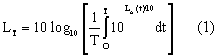
where T is the length of the time
period, in seconds, during which the average is taken; LA(t)
is the instantaneous time varying A-weighted sound level during the time
period T.
Note: When a noise environment is caused by a
number of identifiable noise events, such as aircraft flyovers, average
sound level may be conveniently calculated from the sound exposure levels
of the individual events occurring within a time period T:
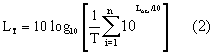
where LAEi is the sound
exposure level of the i-th event, in a series of n events in time period
T, in seconds.
Note: When T is one hour, LT is
referred to as one-hour average sound level.
(b) Day-night average sound level (individual day) must
be computed in accordance with the following formula:
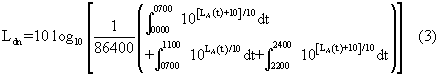
Time is in seconds, so the limits shown
in hours and minutes are actually interpreted in seconds. It is often
convenient to compute day-night average sound level from the one-hour
average sound levels obtained during successive hours.
(c) Yearly day-night average sound level
must be computed in accordance with the following formula:
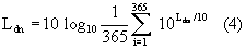
where Ldni is the day-night
average sound level for the i-th day out of one year.
(d) Sound exposure level must be
computed in accordance with the following formula:
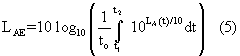
where to is one second and LA(t)
is the time-varying A-weighted sound level in the time interval t1
to t2.
The time interval should be sufficiently
large that it encompasses all the significant sound of a designated event.
The requisite integral may be
approximated with sufficient accuracy by integrating LA(t)
over the time interval during which LA(t) lies within 10
decibels of its maximum value, before and after the maximum occurs.
[Doc. No. 18691, 49 FR 49269, Dec. 18, 1984; 50
FR 5064, Feb. 6, 1985, as amended by Amdt. 150-1, 53 FR 8724, Mar. 16,
1988]