|
Products For Pilots: PocketFMSDuring the rise of the Internet a new concept developed that all kinds of services were available to all for free. Unfortunately, with the burst of the Internet bubble, most of these free services became paying or were seriously limited. Fortunately there are still some small groups of enthusiasts and volunteers that provide free material: the Linux operating system is probably the best known, but also for the aviation community there are some great free tools and websites. Probably the most advanced of these tools is PocketFMS which is available for free on http://www.pocketFMS.com, although a donation through PayPal is greatly appreciated by the authors. The software consist of two parts: a desktop application that can be used for flight planning, and a PocketPC application that you can take to the airport, or even in the plane during the flight if you have a GPS receiver that send data to the pocket PC in NMEA format. The portable version has basically the same functionality as the desktop version, but the larger screen on the desktop is easier for planning the flight and looking at the current weather depictions. The database with the NavData is also maintained by volunteers, and as such not an official pre-flight source. This makes that double-checking with current maps and NOTAMs remains necessary although the database is very accurate and recent. Also TFRs are not maintained in the NavData, but for the rest, it is complete with IFR and VFR reporting points, Navaids, frequencies, airport information... Besides the aeronautical information, there is also some basic VFR mapping, which is improved if you donate. Planning a flight is easy: you enter the departure and destination airports, and a line will be drawn on the map. If you see that this crosses traffic zones or area’s that you want to avoid, there are two options: you either rubber-band yourself using the mouse, or you let PocketFMS calculate a route itself. I have to say that this feature doesn’t always give the best results, and it is more efficient to use the first option. Once you have made your route the EET is calculated based on the actual winds if you can connect to the Internet. Once you know how long it will take you can enter the fuel in the weight and balance to conclude your flight planning. In flight you can attach the GPS, and follow the airplane as you move along. I used it once in flight, and have to admit that it works great if you can set it up on beforehand or just use the moving map function. This is already a lot for a pilot like me that is used to only using VORs and visual waypoints to navigate. On the other hand is a typical PocketPC a fragile device that hasn’t the “turbulence-proof” buttons a ‘real’ aviation GPS has. Off course a pocket PC and GPS-combination costs half of a basic VFR colour-GPS with the same functionality. After the flight you can re-examine what you did by uploading the breadcrumbs file to your PC. In conclusion: PocketFMS is a great tool to use before in and after the flight that doesn’t need to use its “donationware”-status to beat many commercial applications.
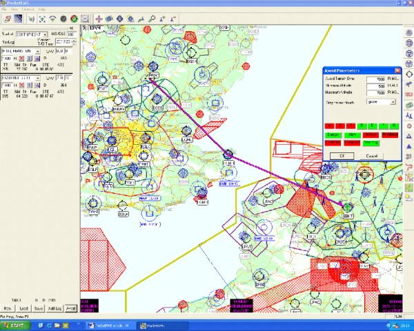
Illustration: The PocketFMS desktop application with a flight between EBKT (Kortrijk, Belgium) to EGSU (Duxford, UK). The Open window allows you to let the application automatically propose a route around the selected area’s. You can select which information you want to see on the screen, and thus further unclutter it.
|