|

fronts
our thanks to http://www.ucar.edu, www.metoffice.com and www.raa.asn.au
air masses
Air masses are parcels of air that bring distinctive weather features to
the country. An air mass is a body or 'mass'of air in which the
horizontal gradients or changes in temperature and humidity are
relatively slight. That is to say that the air making up the mass is very
uniform in temperature and humidity.
An air mass is separated from an adjacent body of air by a transition
that may be more sharply defined. This transition zone or boundary is
called a front. An air mass may cover several millions of square
kilometres and extend vertically throughout the troposphere.
|
Weather
Phenomenon |
Prior to
the Passing of the Front |
Contact
with the Front |
After the
Passing of the Front |
| Temperature |
Warm |
Cooling suddenly |
Cold and getting
colder |
| Atmospheric
Pressure |
Decreasing
steadily |
Levelling off then
increasing |
Increasing
steadily |
| Winds |
South to southeast |
Variable and gusty |
West to northwest |
| Precipitation |
Showers |
Heavy rain or
snow, hail sometimes |
Showers then
clearing |
| Clouds |
Cirrus and
cirrostratus changing later to cumulus and cumulonimbus |
Cumulus and
cumulonimbus |
Cumulus |
The temperature of an air
mass will depend largely on its point of origin, and its subsequent
journey over the land or sea. This might lead to warming or cooling by the
prolonged contact with a warm or cool surface. The processes that warm or
cool the air mass take place only slowly, for example it may take a week
or more for an air mass to warm up by 10 °C right through the troposphere.
For this to take place, an air mass must lie virtually in a stagnant state
over the influencing region. Hence, those parts of the Earth's surface
where air masses can stagnate and gradually attain the properties of the
underlying surface are called source regions.
The main source regions
are the high pressure belts in the subtropics, which produce tropical air
masses, and around the poles, that are the source of polar air masses.
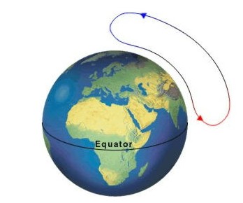
Polar and tropical source regions: The blue and red
arrows show the polar and tropical regions respectively.
modification of air
masses
As we have seen, it is in the source regions that the air mass acquires
distinctive properties that are the characteristics of the underlying
surface. The air mass may be cool or warm, or dry or moist. The stability
of the air within the mass can also be deducted. Tropical air is unstable
because it is heated from below, while polar air is stable because it is
cooled from below.
As an air mass moves away from its source region towards the British
Isles, the air is further modified due to variations in the type or
nature of the surface over which it passes. Two processes act
independently, or together, to modify an air mass.
An air mass that has a maritime track, i.e. a track predominantly over
the sea, will increase its moisture content, particularly in its lower
layers. This happens through evaporation of water from the sea surface.
An air mass with a long land or continental track will remain dry.
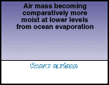 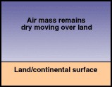
Fig 2:
Modification of air mass by land and ocean surfaces
A cold air mass flowing
away from its source region over a warmer surface will be warmed from
below making the air more unstable in the lowest layers. A warm air mass
moving over a cooler surface is cooled from below and becomes stable in
the lowest layers.
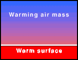 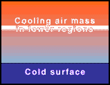
Fig 3:
Modification of air mass due to surface temperature
If we look at the
temperature profiles of the previous example, the effects of warming and
cooling on the respective air masses are very different.
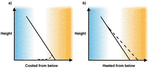
Fig 4:
Modified vertical temperature profiles (----- line) typical of: a)
tropical air cooled from below and b) polar air heated from below on its
way south. Note that where the air is heated from below the effect is
spread to a greater depth of the atmosphere.
weather in an air mass
Five basic types of air masses determine the weather. They can bring
anything from scorching heat to bone-chilling cold depending on the type
of air mass.
These air masses are:
|
Tropical
continental
(Tc)
|
Polar
continental
(Pc)
|
Tropical
maritime
(Tm)
|
Polar
Maritime
(Pm)
|
Arctic
Maritime
(Am)
|
Returning
Polar
Maritime
(rPm)
|
| |
Summer
|
Winter
|
Long sea track
|
Short sea
track
|
Exposed
|
Sheltered
|
|
|
|
| Temp |
Very warm or hot
|
Average
|
Cold
|
Very cold
|
Near sea
temperature
|
Warm
|
Rather cold
|
Cold
(colder
than Pm)
|
Warm
(warmer
than Pm)
|
| Humidity |
Relatively dry
|
Rather moist
|
Moist in lowest layers
|
Very dry
|
Very moist
|
Moist
|
Moist
|
Fairly moist (not as
moist as Pm)
|
Fairly moist (not as
moist as Pm)
|
| Change of lapse
rate |
Little change
|
Cooled from below
|
Heated from below
|
Little change
|
Cooled from below
|
Warmed in summer
|
Heated from below
|
Heated from below
|
Heated from below
|
| Stability |
Generally stable
|
Stable
|
Unstable
|
Stable
|
Stable
|
Stable aloft
|
Unstable
|
Unstable
|
Unstable
|
| Weather |
Clear, occasional thundery showers
|
Clear
|
Rain or snow showers
|
Clear
|
Low cloud, drizzle
|
Broken cloud, dry
|
Variable cloud, showers
|
Showers (mainly coastal)
|
Showers (mainly coastal)
|
| Visibility |
Moderate or poor
|
Moderate of poor
|
Good
|
Moderate or poor
|
Often poor with coastal fog
|
Moderate
|
Good
|
Very good
|
Very good
|
polar front
Several fronts and
semipermanent high and low pressure systems characterize the Arctic. The
"polar front" marks the boundary between cold polar air masses and warm
tropical air masses. The polar front is intermittent rather than
continuous around the globe. The strength of the polar front depends on
the magnitude of the horizontal temperature gradient across the front.
Where the temperature gradient is steep, the front is strong and is a
potential site for cyclone or low pressure system development. Where
temperature contrast is small, the polar front is weak.
Like the polar front, the
"arctic front" is discontinuous and depends on the temperature contrast
between two air masses. The arctic front is the boundary between polar and
arctic air masses and lies to the north of the polar front. The arctic
front can be as strong as the polar front. It is particularly prominent
during summer in northern Eurasia.
Semipermanent high and low
pressure systems ("highs" and "lows") are identified with particular
regions and have seasonal characteristics. In winter, the Icelandic Low
extends from near Iceland north into the Barents Sea, and is associated
with frequent cyclone activity. The Aleutian Low is present in the Gulf of
Alaska. The Beaufort-Chukchi Sea region is dominated by a ridge of high
pressure linking the Siberian High and high pressure over the Yukon of
Canada. In April and May arctic pressure gradients decrease. The Icelandic
and Aleutian lows weaken. The Siberian High disappears, and is replaced by
a wide but shallow low. The Arctic High is centred over the Canadian
Arctic Archipelago. In summer, pressure gradients are generally weak.
Intermittently, however, cyclones enter the Arctic from northern Eurasia
and the north Atlantic, and tend to persist over the Canadian Basin. By
October the pattern has almost returned to the winter configuration. The
Icelandic and Aleutian lows strengthen, as does the Siberian High.
Semipermanent Highs and Lows
The Arctic is
characterized by "semipermanent" patterns of high and low pressure. These
patterns are semipermanent because they appear in charts of long-term
average surface pressure. They can be considered to largely represent the
statistical signature of where transitory high and low systems that appear
on synoptic charts tend to be most common.
Aleutian Low
This semipermanent low
pressure centre is located near the Aleutian Islands. Most intense in
winter, the Aleutian Low is characterized by many strong cyclones.
Travelling cyclones formed in the subpolar latitudes in the North
Pacific usually slow down and reach maximum intensity in the area of the
Aleutian Low.
Icelandic Low
This low pressure center
is located near Iceland, usually between Iceland and southern Greenland.
Most intense during winter, in summer, it weakens and splits into two
centres, one near Davis Strait and the other west of Iceland. Like its
counterpart the Aleutian Low, it reflects the high frequency of cyclones
and the tendency for these systems to be strong. In general, migratory
lows slow down and intensify in the vicinity of the Icelandic Low.
Siberian High
The Siberian High is an
intense, cold anticyclone that forms over eastern Siberia in winter.
Prevailing from late November to early March, it is associated with
frequent cold air outbreaks over east Asia.
Beaufort High
The Beaufort High is a
high pressure centre or ridge over the Beaufort Sea present mainly in
winter.
North American High
The North American High
is a relatively weak area of high pressure that covers most of North
America during winter. This pressure system tends to be centred over the
Yukon, but is not as well-defined as its continental counterpart, the
Siberian High.
Polar Lows
Small cyclones forming
over open sea during the cold season within polar or arctic air masses
are called "polar lows." Typically several hundred kilometers in
diameter, and often possessing strong winds, polar lows tend to form
beneath cold upper-level troughs or lows when frigid arctic air flows
southward over a warm body of water.
Polar lows last on
average only a day or two. They can develop rapidly, reaching maximum
strength within 12 to 24 hours of the time of formation. They often
dissipate just as quickly, especially upon making landfall. In some
instances several may exist in a region at the same time or develop in
rapid succession.
In satellite imagery
polar lows show characteristic spiral or comma shaped patterns of deep
clouds, sometimes with an inner "eye" similar to those seen in tropical
cyclones. Convective cloud bands occupy the surroundings (see figure
below). Analysis of aircraft and radiosonde data collected during field
experiments reveals that polar lows may possess warm cores. This
finding, coupled with their appearance in satellite imagery, has
prompted some investigators to refer to polar lows as "arctic
hurricanes," although they seldom, if ever, possess hurricane strength
winds.
Polar lows are difficult
to predict even with current high resolution and high performing
operational numerical models, because they usually occur in remote
oceanic regions where data are too sparse to define the model initial
state on a sufficiently fine scale. However, present-day models can
depict synoptic-scale patterns favourable to the development of the
smaller scale systems, allowing forecasters to use the predictions in
conjunction with satellite imagery and conventional observations to make
subjective forecasts of their occurrence.
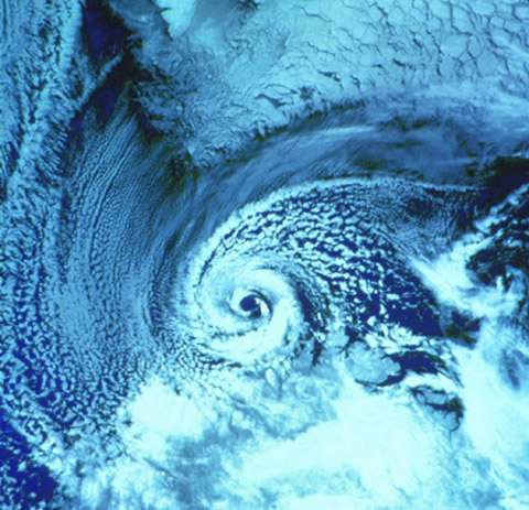
A NOAA-9 polar orbiter
satellite image (visible band) of a polar low over the Barents Sea on
27 February 1987. The southern tip of Spitsbergen is visible at the
top of the image. The polar low is centred just north of the Norwegian
coast. Image contributed by S. Businger, Department of Meteorology,
University of Hawaii.
The Polar Vortex
The polar vortex is a
persistent large-scale cyclonic circulation pattern in the middle and
upper troposphere and the stratosphere, centred generally in the polar
regions of each hemisphere. In the Arctic, the vortex is asymmetric and
typically features a trough (an elongated area of low pressure) over
eastern North America. It is important to note that the polar vortex is
not a surface pattern. It tends to be well expressed at upper levels of
the atmosphere (that is, above about five kilometres).
fronts
A front is defined as the transition zone between two air masses of
different density. Fronts extend not only in the horizontal direction, but
in the vertical as well. Therefore, when referring to the frontal surface
(or frontal zone), we referring to both the horizontal and vertical
components of the front.
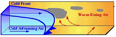
A cold front is that part (or parts) of
a frontal system along which cold air is advancing and is coloured blue on the
weather map.
A warm front is that part (or parts) of
a frontal system along which cold air is retreating and is coloured red on the
weather map.
types of
front
the warm front
A warm
front is defined as the transition zone where a warm air mass is replacing a
cold air mass. Warm fronts generally move from southwest to northeast and
the air behind a warm front is warmer and more moist than the air ahead of
it. When a warm front passes through, the air becomes noticeably warmer and
more humid than it was before.
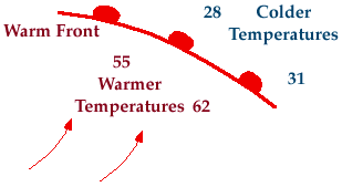
Symbolically, a warm front is represented
by a solid line with semicircles pointing towards the colder air and in the
direction of movement. On coloured weather maps, a warm front is drawn with
a solid red line.
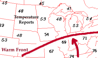
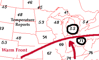
There is typically a noticeable
temperature change from one side of the warm front to the other. In the map
of surface temperatures below, the station north of the front reported a
temperature of 53 degrees Fahrenheit while a short distance behind the
front, the temperature increased to 71 degrees. An abrupt temperature change
over a short distance is a good indication that a front is located somewhere
in between.
If warmer air is replacing colder air,
then the front should be analyzed as a warm front. If colder air is
replacing warmer air, then the front should be analyzed as a cold front.
Common characteristics associated with warm fronts have been listed in the
table below.
| |
|
Before Passing |
|
While Passing |
|
After Passing |
| Winds |
|
south-southeast |
|
variable |
|
south-southwest |
| Temperature |
|
cool-cold, slow warming |
|
steady rise |
|
warmer, then steady |
| Pressure |
|
usually falling |
|
levelling off |
|
slight rise, followed
by fall |
| Clouds |
|
in this order: Ci, Cs, As, Ns, St,
and fog; occasionally Cb in summer |
|
stratus-type |
|
clearing with
scattered Sc; occasionally Cb in summer |
| Precipitation |
|
light-to-moderate rain, snow,
sleet, or drizzle |
|
drizzle or none |
|
usually none,
sometimes light rain or showers |
| Visibility |
|
poor |
|
poor, but improving |
|
fair in haze |
| Dew Point |
|
steady rise |
|
steady |
|
rise, then steady |
As a mass of warm air advances
on a retreating mass of cold air, the warm air, being lighter, ascends over
the cold air in a long gentle slope. As a result, the cloud formation
associated with the warm frontal system may extend for 500 or more nautical
miles in advance of it. Warm fronts usually move at relatively slow speeds and
therefore affect a vast area for a considerable length of time.
If the warm air is moist and
stable, stratiform clouds develop in a
distinctive sequence. The first signs of an approaching warm front are high
cirrus clouds which thicken to cirrostratus and altostratus as the warm front
approaches. The ceiling gradually falls and there follows a long belt of
steady rain falling from heavy nimbostratus cloud. Precipitation may lead the
frontal surface by as much as 250 nautical miles.
If the warm air is moist and
somewhat unstable, cumulonimbus and thunderstorms may be embedded in the
stratiform layers. Heavy showers in advance of the surface front can then be
expected.
Very low stratus clouds and fog
throughout the frontal zone are typical characteristics of warm
fronts.
The passing of the warm front is
marked by a rise of temperature, due to the entry of the warm air, and the sky
becomes relatively clear.
the cold front
A cold front is defined
as the transition zone where a cold air mass is replacing a warmer air
mass. Cold fronts generally move from northwest to southeast. The air
behind a cold front is noticeably colder and drier than the air ahead of
it. When a cold front passes through, temperatures can drop more than 15
degrees within the first hour.
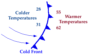
Symbolically, a cold front is represented
by a solid line with triangles along the front pointing towards the
warmer air and in the direction of movement. On coloured weather maps, a
cold front is drawn with a solid blue line.
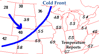
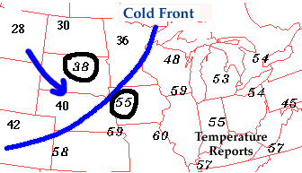
There is typically a
noticeable temperature change from one side of a cold front to the
other. In the map of surface temperatures below, the station east of the
front reported a temperature of 55 degrees Fahrenheit while a short
distance behind the front, the temperature decreased to 38 degrees. An
abrupt temperature change over a short distance is a good indicator that
a front is located somewhere in between.
If colder air is
replacing warmer air, then the front should be analyzed as a cold front.
On the other hand, if warmer air is replacing cold air, then the front
should be analyzed as a warm front. Common characteristics associated
with cold fronts have been listed in the table below.
| |
|
Before Passing |
|
While Passing |
|
After Passing |
|
Winds |
|
south-southwest |
|
gusty; shifting |
|
west-northwest |
|
Temperature |
|
warm |
|
sudden drop |
|
steadily dropping |
|
Pressure |
|
falling steadily |
|
minimum, then sharp rise |
|
rising steadily |
|
Clouds |
|
increasing: Ci, Cs and Cb |
|
Cb |
|
Cu |
|
Precipitation |
|
short period of showers |
|
heavy rains, sometimes with hail, thunder and lightning |
|
showers then clearing |
|
Visibility |
|
fair to poor in haze |
|
poor, followed by improving |
|
good, except in showers |
|
Dew
Point |
|
high; remains steady |
|
sharp drop |
|
lowering |
When a mass of cold air overtakes a mass of
warm air, the cold air being denser, stays on the surface and undercuts the
warm air violently. Surface friction tends to slowdown the surface air while a
sharp fall in temperature, a rise in pressure and rapid clearing usually occur
with the passage of the cold front.
Sometimes, an advancing cold
front will be relatively slow moving. Because it does not undercut the warm
air so violently, a rather broad band of clouds develops extending a fair
distance behind the frontal surface. If the warm air is stable, these clouds
will be stratiform; if the warm air is unstable, they are cumuliform and
possibly thunderstorms. With passage of the frontal surface, clearing is more
gradual.
the stationary front
There is generally some part of
a front along which the colder air is neither advancing nor retreating. There
is no motion to cause the front to move because the opposing air masses are of
equal pressure. The surface wind tends to blow parallel to the front and the
weather conditions are similar to those associated with a warm front although
generally less intense and not so extensive. Usually a stationary front will
weaken and eventually dissipate. Sometimes, however, after several days, it
will begin to move and then it becomes either a warm front or a cold
front.
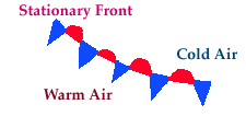
A noticeable temperature change and/or shift
in wind direction is commonly observed when crossing from one side of a
stationary front to the other.
In the map above, temperatures south of the
stationary front were in the 50's and 60's with winds generally from the
southeast. However, north of the stationary front, temperatures were in the
40's while the winds had shifted around to the northeast. Cyclones migrating
along a stationary front can dump heavy amounts of precipitation, resulting in
significant flooding along the front
occluded fronts
When the progress of time as a
depression advances, the cold front gradually overtakes the warm front and
lifts the warm sector entirely from the ground. It is simply a case of the
cold air catching up with itself as it flows around the depression. Thus only
one front remains, which is called an occluded front or occlusion. An occluded
depression soon commences to fill up and die away.
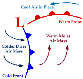
A developing cyclone typically has a preceding
warm front (the leading edge of a warm moist air mass) and a faster moving
cold front (the leading edge of a colder drier air mass wrapping around the
storm). North of the warm front is a mass of cooler air that was in place
before the storm even entered the region.
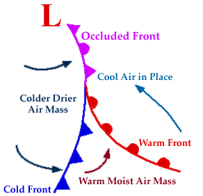
As the storm intensifies, the cold front
rotates around the storm and catches the warm front. This forms an occluded
front, which is the boundary that separates the new cold air mass (to the
west) from the older cool air mass already in place north of the warm front.
Symbolically, an occluded front is represented by a solid line with
alternating triangles and circles pointing the direction the front is moving.
On coloured weather maps, an occluded front is drawn with a solid purple line.
Changes in temperature, dew point temperature,
and wind direction can occur with the passage of an occluded front. In the map
below, temperatures ahead (east of) the front were reported in the low 40's
while temperatures behind (west of) the front were in the 20's and 30's. The
lower dew point temperatures behind the front indicate the presence of drier
air.
A noticeable wind shift also occurred across
the occluded front. East of the front, winds were reported from the
east-southeast while behind the front, winds were from the west-southwest.
Common characteristics associated with occluded fronts have been listed in the
table below.
| |
|
Before Passing |
|
While Passing |
|
After Passing |
|
Winds |
|
southeast-south |
|
variable |
|
west
to northwest |
Temperature
Cold Type
Warm Type |
|
cold-cool
cold |
|
dropping
rising |
|
colder
milder |
|
Pressure |
|
usually falling |
|
low point |
|
usually rising |
|
Clouds |
|
in order: Ci,
Cs, As, Ns |
|
Ns, sometimes
Tcu and Cb |
|
Ns,
As or scattered Cu |
|
Precipitation |
|
light, moderate
or heavy precipitation |
|
light, moderate
or heavy continuous precipitation or showers |
|
light-to-moderate precipitation followed by general clearing |
|
Visibility |
|
poor in
precipitation |
|
poor in
precipitation |
|
improving |
|
Dew Point |
|
steady |
|
usually slight
drop, especially if cold-occluded |
|
slight drop, although may rise a bit if warm-occluded |
The cold air, in the distance it
has travelled, may have undergone considerable change. Therefore it may not be
as cold as the air it is overtaking. In this case (cool air advancing on
colder air), the front is known as an occluded warm front or a warm occlusion
and has the characteristics of a warm front, with low cloud and continuous
rain and drizzle. It the warm air is unstable, heavy cumulus or cumulonimbus
cloud may be embedded in the stratiform cloud bank.
It the cold air is colder than
the air it is overtaking (cold air advancing on cool air), the front is known
as an occluded cold front or a cold occlusion. A cold occlusion has much the
same characteristics as a warm front, with low cloud and continuous rain. If
the warm air is unstable, cumulonimbus and thunderstorms are likely to occur,
with the violent turbulence, lightning and icing conditions associated with
these clouds.
It will be noted that in the case of either a
warm or cold occlusion, three air masses are present, a cool air mass
advancing on a cold air mass, or a cold air mass advancing on a cool air mass,
with, in either case, a warm air mass lying wedge shaped over the colder air.
This wedge shaped mass of warm air is known as a trowel in Canada. (In some
other countries, such as the US, it is called an upper front.)
upper fronts
In Canada, the term upper front
refers to a non-occlusion situation. Sometimes, cold air advancing
across the country may encounter a shallow layer of colder air resting on the
surface or trapped in a topographical depression. The advancing cold air rides
up over the colder, heavier air. The cold front which is the leading edge of
the advancing cold air, therefore, leaves the ground and moves along the top
of the colder air. It is then known as an upper cold front.
Sometimes, the structure of the
advancing cold front is such that the cold air forms a shallow layer for some
distance along the ground in advance of the main body of cold air. The frontal
surface If the main mass of cold air, in this situation, will usually be very
steep. The line along which the frontal surface steepens is also known as an
upper cold front.
On occasion, an advancing warm
front rides up over a pool or layer of cold air trapped on the ground. A
station on the ground does not experience a change of air mass because the
front passes overhead. This is known as an upper warm front.
Sometimes, the surface of the
cold air that is retreating ahead of an advancing warm front is almost flat
for some distance ahead of the surface front and then steepens abruptly. The
line along which the surface of the retreating cold air steepens sharply is
also called an upper warm front.
frontal weather
The theory of the polar front,
which for the sake of simplicity has been described in the form of its
original conception, might leave the impression that depressions form only
along some well defined line Iying somewhere midway between the poles and the
equator. Air masses are in a constant state of formation over all the land and
water areas of the world. Once formed, they tend to move away from the source
regions over which they form. The same frontal processes and phenomena occur
whenever a mass of warm air and a mass of cold air come in contact.
There is a widespread impression
among pilots that fronts always bring bad weather and that all bad weather is
frontal. Actually some fronts have little or no weather associated with them.
A slight change of temperature and a windshift may be the only evidence that
the front has gone through. And, of course, bad weather can develop without
the passage of a front. Fog, for example, generally occurs when no fronts are
present and severe thunderstorms may develop in an air mass, which has no
frontal characteristics.
Another common misconception is
that the front is a thin wall of weather. This false idea is perhaps
occasioned by the line that indicates a front on a weather map. The line on
the map only shows the surface location at which the pressure change,
windshift and temperature change occur. The actual weather associated with the
front may extend over an area many miles in width, both well ahead and also
for many miles behind the actual line on the weather map.
A front itself is actually a
transition zone between two large air masses with different properties of
temperature and moisture. Each individual air mass may extend over hundreds of
thousands of square miles. Everywhere along the boundary of an air mass, where
it overrides or undercuts the air mass upon which it is advancing and for a
considerable height upward from the surface as well, there is a frontal zone.
The frontal weather associated with the front, therefore, can be expected to
extend for hundreds of miles along the boundary of the air
mass.
Frontogenesis
means a
front, which is increasing in intensity.
Frontolysis means a
front, which is decreasing in intensity.
If you examine the diagrams
showing fronts on a weather map, you will notice that all fronts lie in
regions of lower pressure. The isobars are bent sharply at a front. These two
factors are characteristic of all fronts.
weather at the cold
front
Cold fronts are not all the
same. The weather associated with a cold front may vary from a minor windshift
to severe thunderstorms, low ceilings, restricted visibility and violent gusty
winds. The severity of the weather is determined by the moisture content and
stability of the warm air mass that the cold air mass is undercutting and the
speed of the advancing cold front.
Fast moving cold fronts may
travel across the country with a speed of 30 knots or more. If the warm
air that is being undercut by the cold air mass is very moist and unstable,
towering cumulus clouds and thunderstorms are likely to develop. Heavy rain or
hail may be associated with the front. A slower moving cold front advancing on
more stable and drier air in the warm sector will produce less severe weather
conditions, stratus or altocumulus clouds with light or no
precipitation.
A long line of cumulus clouds on
the western horizon is usually an indication of an approaching cold front.
Sometimes a deck of altocumulus cloud or decks of stratus and stratocumulus
extending ahead of the front will mask the main frontal cloud from the view of
the high flying or low flying pilot respectively.
weather changes
Surface Wind:
The wind direction will always veer as the front passes. Gustiness may be
associated with the windshift.
In flying through a cold front,
the windshift may be quite abrupt and occurs at the frontal surface rather
than at the front. The windshift is always such that an alteration in course
to starboard is required, no matter which way you are flying through the
front.
Temperature: On the
ground, the temperature may drop sharply as the front passes, but usually
it drops gradually. The air immediately behind the front has been warmed
in passing over the warm ground. Therefore, it may be several hours before
the temperature drops to the true value of the cold air mass. In flying
through a cold front, there will be a noticeable temperature change when
passing through the frontal surface.
Visibility: Visibility
usually improves after passage of a cold front. If the front is moving
fairly rapidly, the width of frontal weather generally is less than 50
miles. If the front is moving slowly, however, flight operations may be
affected for many hours.
Pressure: The approach of
a cold front is accompanied by a decrease in pressure. A marked rise will
be noticed when the front has passed.
Turbulence: Turbulence
may be associated with the cold front if it is active, although
thunderstorms are not always present. Even in cases where there are no
clouds, turbulence may be a problem. As a rule, flight through an active
cold front can be expected to be rough.
Precipitation: The
frontal rain or snow is usually narrow, especially if it is showery in
character. Icing in the turbulent cumulus clouds can be
severe.
line squalls
A long line of squalls and
thunderstorms which sometimes accompanies the passage of a cold front is
called a line squall (or squall line). It is usually associated with a fast
moving cold front that is undercutting an unstable warm air mass. It may form
anywhere from 50 to 300 nautical miles in advance of the front itself. The
line squall is a long line of low black, roller like cloud, which often
stretches in a straight line for several hundred miles, and from which heavy
rain or hail falls for a short time. Thunder and lightning frequently occur.
The squall is also accompanied by a sudden wind change from southerly or
south-westerly to north or north-westerly, together with a sudden drop in
temperature and a rise in barometric pressure. The actual wind squall lasts
only for a few minutes but is often extremely violent, constituting a serious
menace both to shipping and to airplanes. The signs indicating the approach of
a line squall are unmistakable. Airplanes on the ground should be immediately
hangared. Those in the air should at all costs avoid this violent weather
phenomenon.
weather at the warm
front
Warm front changes are usually
less pronounced than cold front changes. The change is also generally very
gradual. However, the weather at a warm front is usually more extensive and
may cover thousands of square miles. A wide variety of weather characterizes
warm fronts. The weather may even vary along a given front.
The degree of overrunning and
the moisture content and stability of the overrunning warm air determine the
seventy of the weather. If the warm air is very moist, the cloud deck forming
in the overrunning air may extend for hundreds of miles up the slope of the
retreating cold air. It the warm air is unstable, thunderstorms may be
embedded in the cloud deck.
High cirrus cloud is the first
sign of the approach of an active warm front. Cirrostratus soon follows (the
high thin cloud which causes a halo around the sun or moon). The cloud
gradually thickens and the base lowers until a solid deck of
altostratus/altocumulus covers the area. Low nimbostratus moves in, merging
with the altostratus. With the result that a solid deck of cloud extending
from near the surface to 25,000 feet or more covers the whole area.
Precipitation is usually heavy.
weather
changes
Windshift: With the
passage of a warm front, the wind will veer, but the change will be much more
gradual than in the case of a cold front.
When flying through a warm
front, the windshift will occur at the frontal surface and will be more
noticeable at lower levels. When flying through a warm front, the windshift is
such that a course alteration to starboard is necessary.
Temperature: The warm front
brings a gradual rise in temperature. A pilot flying through the frontal
surface will notice a more abrupt temperature rise.
Visibility: Low ceilings
and restricted visibility are associated with warm fronts and, because warm
fronts usually move quite slowly, these conditions persist for considerable
time.
When rain falls from the
overrunning warm air, masses of irregular cloud with very low bases form in
the cold air. Fog is frequently a condition 50 nautical miles ahead of an
advancing warm front.
Turbulence: Cumulonimbus
clouds are frequently embedded in the main cloud deck and these storms are
responsible for the most severe turbulence associated with a warm front.
However, these storms and the turbulence they occasion are less severe than
those associated with cold fronts. The principal problem with these storms
is that they cannot be located by sight since they are embedded in the main
cloud cover.
Precipitation: The first
precipitation begins in the region where the altostratus layer of cloud is
from 8000 to 12,000 feet above the ground. As the front approaches, the
precipitation becomes heavier. Occasional very heavy precipitation is an
indication of the presence of thunderstorms.
winter warm fronts
In winter, when temperatures in
the cold air are below freezing and temperatures in the lower levels of the
warm air are above freezing, snow and freezing rain can be
expected.
Snow falls from that part of the
warm air cloud that is high and therefore below freezing in temperature. From
the lower cloud, where temperatures are above freezing, rain falls. However,
as the rain falls through the cold air (of the cold air mass that the warm air
is overrunning), it becomes supercooled and will freeze on contact with any
cold object. This is known as freezing rain (ZR).
In the area ahead of the
freezing rain, there is a region where the rain falling through the cold air
becomes sufficiently supercooled to freeze and falls to the ground as ice
pellets (IP). A pilot approaching the frontal surface at higher altitudes may
not encounter the ice pellets, but the pilot flying at quite low altitudes can
expect to encounter snow, ice pellets and then freezing rain.
Icing is a problem associated
with warm fronts in winter. Snow is not responsible for icing, unless it is
very wet when it can stick to an airplane and form ice. Freezing rain,
however, causes a rapid build up of ice. Icing will also be a problem in the
cloud layers.
weather at trowals and upper fronts
The weather that occurs with a
trowal is a combination of cold and warm front conditions. The cloud pattern
ahead of the approaching trowel is similar to that of a warm front. Cold front
cloud formations will exist behind it. Cumulus buildups and thunderstorms are
likely to be interspersed with stratiform clouds, continuous precipitation and
widespread low ceilings. In winter months, freezing rain and severe icing
conditions are likely hazards as the rain aloft in the occluded warm air falls
through the freezing temperatures of the ground based cold sectors. The
maximum precipitation, convective activity and icing conditions usually occur
in the northeast sector of the low and extend some 50 to 100 miles ahead of
the occluded front.
|
|
