
introduction
Navigation is the art and science of getting from
point "A" to point "B" in the least possible time without losing your way. In
the early days of aviation, navigation was mostly an art. The simplest
instruments of flight had not been invented, so pilots flew "by the seat of
their pants". Today, navigation is a science with sophisticated equipment being
standard on most aircraft.
The type of navigation used by pilots
depends on many factors. The navigation method used depends on where the pilot
is going, how long the flight will take, when the flight is to take off, the
type of aircraft being flown, the on-board navigation equipment, the ratings and
currency of the pilot and especially the expected weather.
To
navigate a pilot needs to know the following:
-
Starting point (point of departure)
-
Ending point (final destination)
-
Direction of travel
-
Distance to travel
-
Aircraft speed
-
Aircraft fuel capacity
-
Aircraft weight & balance information
With this information flight planning can commence and the proper method of
navigation can be put to use.
Basic Navigation
Pilotage
For
a non-instrument rated, private pilot planning to fly VFR (Visual Flight Rules)
in a small, single engine airplane around the local area on a clear day, the
navigation is simple. The navigation process for such a local trip would be
pilotage. (Bear in mind, however that the flight planning and preflight for such
a trip should be as thorough as if the pilot is preparing to fly
cross-country.)
The pilotage method of navigation developed naturally through time as
aircraft evolved with the ability to travel increasingly longer distances.
Flying at low altitudes, pilots used rivers, railroad tracks and other visual
references to guide them from place to place. This method called pilotage is
still in use today. Pilotage is mainly used by pilots of small, low speed
aircraft who compare symbols on aeronautical charts with surface features on the
ground in order to navigate. This method has some obvious disadvantages. Poor
visibility caused by inclement weather can prevent a pilot from seeing the
needed landmarks and cause the pilot to become disoriented and navigate off
course. A lack of landmarks when flying over the more remote areas can also
cause a pilot to get lost.
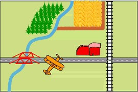
Using pilotage for navigation can be as easy
as following an interstate highway. It would be difficult to get lost flying VFR
from Oklahoma City to Albuquerque on a clear day because all a pilot need do is
follow Interstate 40 west. Flying from Washington, DC to Florida years ago was
accomplished by flying the "great iron compass" also called the railroad
tracks.
Dead Reckoning
"Dead" Reckoning (or "Ded" for
Deductive Reckoning) is another basic navigational method used by low speed,
small airplane pilots. It is based on mathematical calculations to plot a course
using the elements of a course line, airspeed, course, heading and elapsed time.
During this process pilots make use of a flight computer. Manual or electronic
flight computers are used to calculate time-speed-distance measurements, fuel
consumption, density altitude and many other en route data necessary for
navigation.
The estimated time en route (ETE) can be calculated using the flight
distance, the airspeed and direction to be flown. If the route is flown at the
airspeed planned, when the planned flight time is up, the destination should be
visible from the cockpit. Navigating using known measured and recorded times,
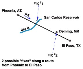
distances, directions and speeds makes it possible for positions or "fixes" to
be calculated or solved graphically. A "fix" is a position in the sky reached by
an aircraft following a specific route. Pilots flying the exact same route
regularly can compute the flight time needed to fly from one fix to the next. If
the pilot reaches that fix at the calculated time, then the pilot knows the
aircraft is on course. The positions or "fixes" are based on the latest known or
calculated positions. Direction is measured by a compass or gyro-compass. Time
is measured on-board by the best means possible. And speed is either calculated
or measured using on-board equipment.
Navigating now by dead reckoning
would be used only as a last resort, or to check whether another means of
navigation is functioning properly. There are navigation problems associated
with dead reckoning. For example, errors build upon errors. So if wind velocity
and direction are unknown or incorrectly known, then the aircraft will slowly be
blown off course. This means that the next fix is only as good as the last
fix.
|
