|
|
|
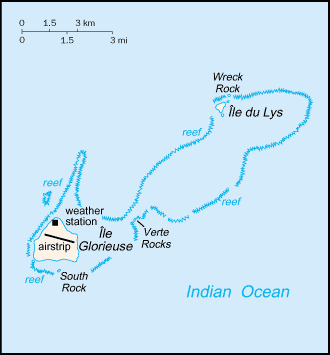
A French possession since 1892, the
Glorioso Islands are composed of two lushly vegetated coral islands (Ile
Glorieuse and Ile du Lys) and three rock islets. A military garrison
operates a weather and radio station on Ile Glorieuse. Southern Africa, group of islands in the
Indian Ocean, northwest of Madagascar 11 30 S, 47 20 E total: 5 sq
km tropical low and flat lowest point:
Indian Ocean 0 m guano, coconuts periodic cyclones the islands and rocks are surrounded by an
extensive reef system no indigenous inhabitants possession of France; administered by a
high commissioner of the Republic, resident in Reunion no economic activity 1 meteorological station none; offshore anchorage only 1 (2003 est.) total: 1 defense is the responsibility of France
claimed by Madagascar |
|
|