|
|
|
Originally
settled by Polynesian emigrants from surrounding island groups, the Tokelau
Islands were made a British protectorate in 1889. They were transferred to
New Zealand administration in 1925. Oceania, group
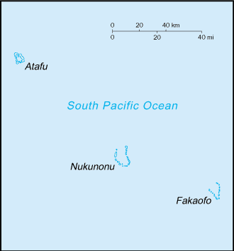
of three atolls in the South Pacific Ocean, about one-half of the way from
Hawaii to New Zealand 9 00 S, 172 00
W total:
10 sq km territorial
sea: 12 nm tropical;
moderated by trade winds (April to November) low-lying
coral atolls enclosing large lagoons lowest
point: Pacific Ocean 0 m lies in
Pacific typhoon belt very limited
natural resources and overcrowding are contributing to emigration to New
Zealand consists of
three atolls, each with a lagoon surrounded by a number of reef-bound islets
of varying length and rising to over three meters above sea level
1,405 (July
2004 est.) Polynesian
Congregational
Christian Church 70%, Roman Catholic 28%, other 2% Tokelauan (a
Polynesian language), English
self-administering territory of New Zealand; note - Tokelauans are drafting
a constitution and developing institutions and patterns of self-government
as Tokelau moves toward free association with New Zealand none; each
atoll has its own administrative center Waitangi Day
(Treaty of Waitangi established British sovereignty over New Zealand), 6
February (1840) administered
under the Tokelau Islands Act of 1948, as amended in 1970 New Zealand
and local statutes Tokelau's
small size (three villages), isolation, and lack of resources greatly
restrain economic development and confine agriculture to the subsistence
level. The people rely heavily on aid from New Zealand - about $4 million
annually - to maintain public services, with annual aid being substantially
greater than GDP. The principal sources of revenue come from sales of copra,
postage stamps, souvenir coins, and handicrafts. Money is also remitted to
families from relatives in New Zealand. stamps, copra,
handicrafts New Zealand
(2000) foodstuffs,
building materials, fuel New Zealand
(2000) from New
Zealand about $4 million annually New Zealand
dollar (NZD) 300 (2002)
0 (2001)
general
assessment: adequate total:
NA km none; offshore
anchorage only none
none; lagoon
landings are possible by amphibious aircraft (2003 est.) |
||||||||||||||||||||||||||||||||||||||||||||||||||||||||||||||||||||||
|
|